
Overview
County: Clare
Total length: 114km
What we walked: 86.5km
Start point: Lahinch
End point: Corrofin
Trail difficulty: 2/5
Trail quality: 2.5/5
Most common walking surfaces: Roads and rocky access lanes
Views/area: 4/5
Camping/accommodation: 4/5
Off Shoots: Lisdoonvarna, Fanore, Black Head, Ballyvaughan, Tubber.
Maps: We’ve made our own Tough Soles maps! These maps are free to use, remix, and redistribute under CC-BY 4.0. All you need to do is attribute us! Here are the Burren Way maps, and here are all the maps we’ve made.
Trail Days:
Day 1: Lahinch - Liscannor // 9.5km
Day 2: Liscannor - Fanore // 32km
Day 3: Fanore - N67 // 20km
Day 4: N67 - Corofin // 25km
The above distances are rough estimates from when we were walking
The Burren Way was our 38th trail when walking all 42 of Ireland’s National Waymarked Trails. Like a few other trails, we had actually attempted to start this one before, but had promptly been washed away by a storm. With a dwindling list of possibilities, it was time to hit the Clare coastline again.
Also - we were lucky on this trail and had the company of friends! Theo became our tour manager for our week down there, providing lifts, unending help, and a walking buddy. We caught up to Elias and Audrey who were also walking the trail for the final leg (huge thanks to the three of you for the company!).
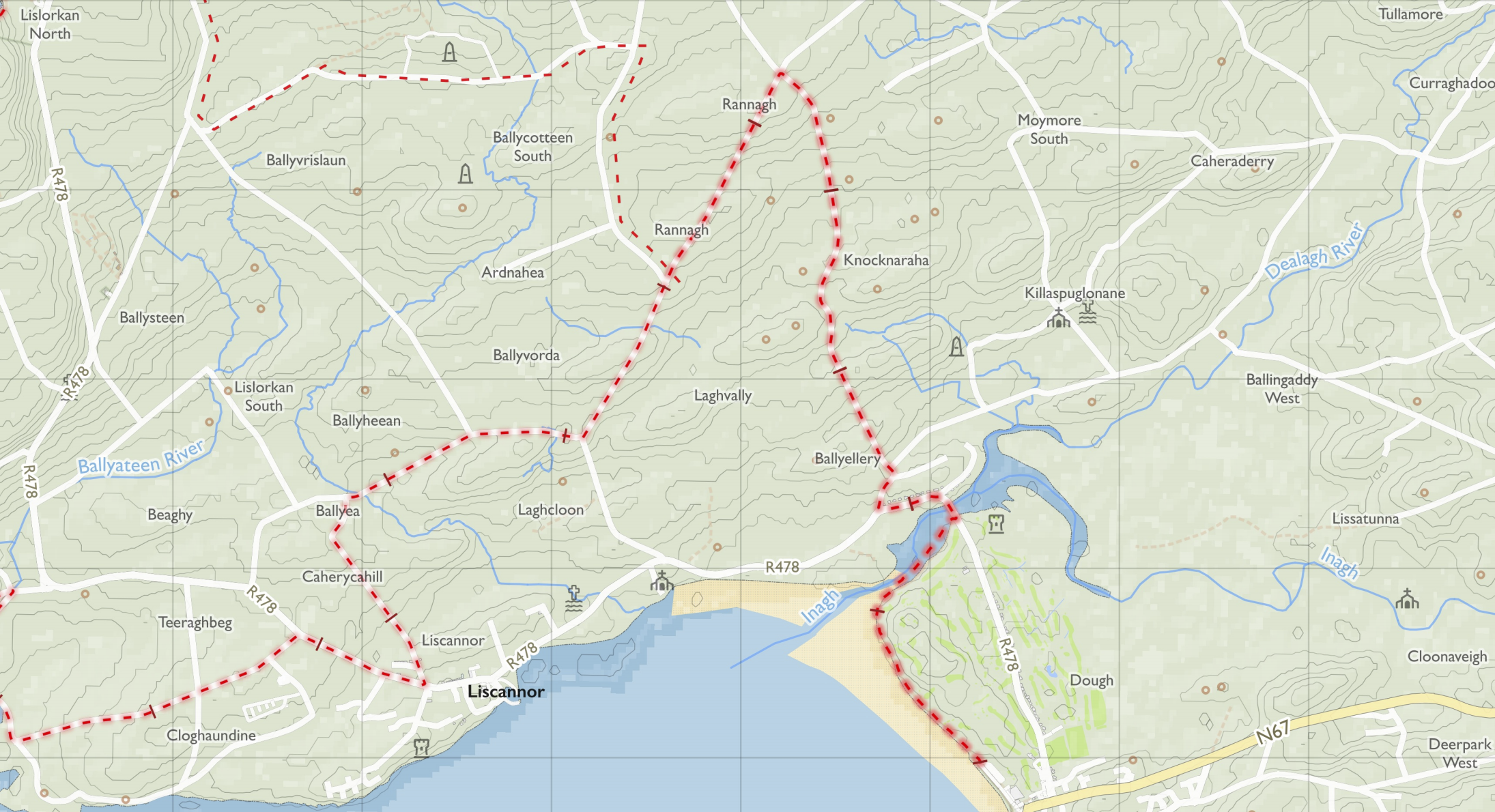
Day 1: Lahinch - Liscannor
On day 1 we arrived into Lahinch late afternoon, so decided to knock just a few kilometres off and head for the next village of Liscannor. When looking at a map, it looks like the trail takes the longest route possible to just stroll up the coast, but the reason for this is that the R478 is a very busy road of speeding cars and tour buses, so the trail tries to avoid it as much as possible.
The first 2km are along lovely beach walking, and with a lowering sun and glistening water we could hardly complain. After some road walking along small lanes we made it into Liscannor and sat at the pier for the sunset.

Day 2: Liscannor - Fanore
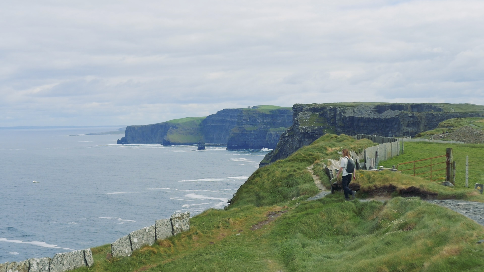
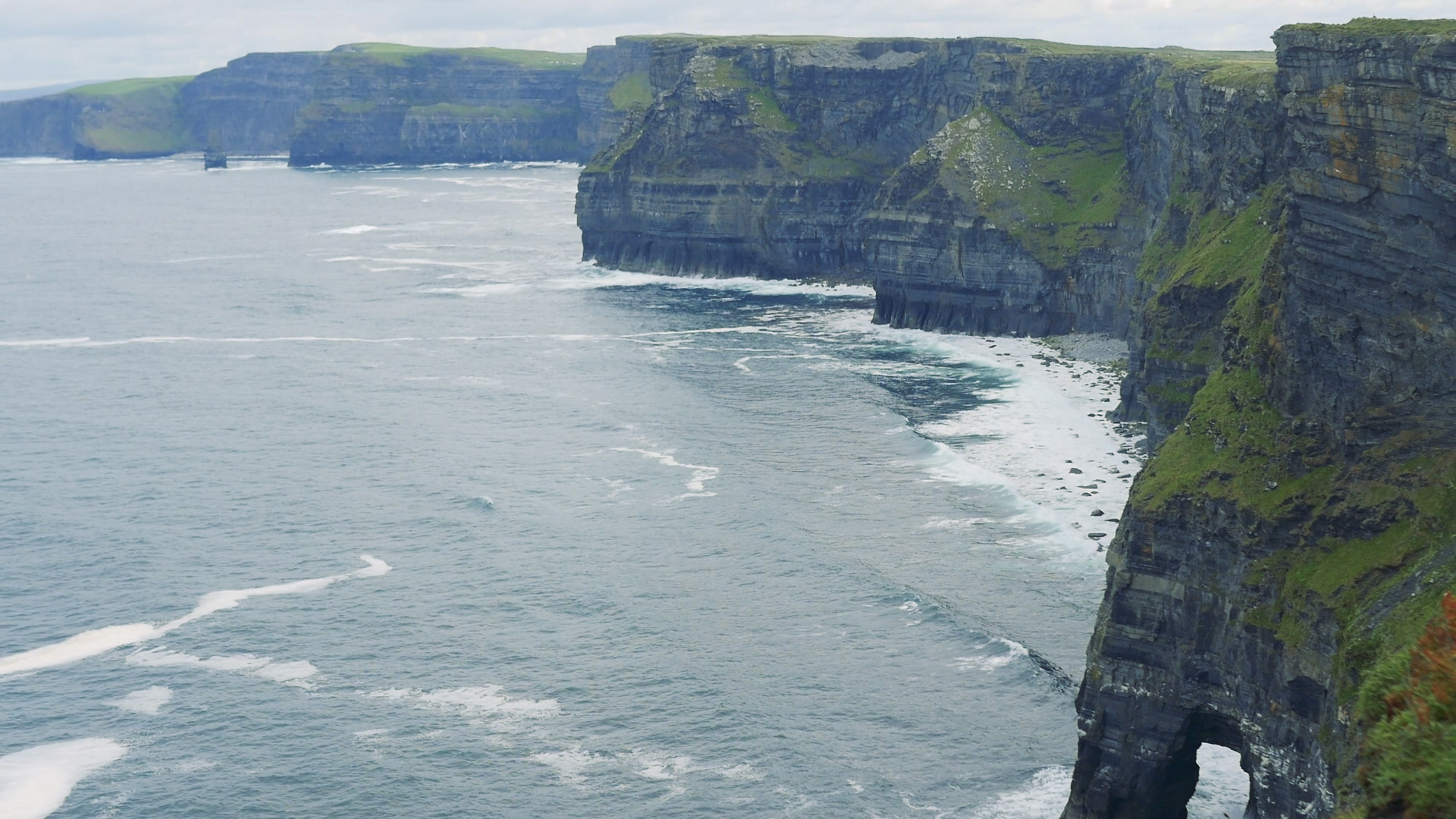
Day 2 was our longest day of walking, covering 32km from Liscannor - Fanore. We grabbed coffee in the village before we set out, walking 6km along roads before hitting the dirt tracks. It was approaching midday as our track reached a drop, and we stood looking out from the top of the Cliffs of Moher. This section of the trail features almost 12km of rugged cliff walking, with loud waves crashing below you and sea birds screeching at each other for better purchase on their crowded outcrops. The sun was beating down, creating a slight haze to the further away cliffs. It was beautiful.

When we first joined the cliffs we were two of less than ten people picking their way along the trail. However, the closer we drew to the cliffs of Moher visitor centre, the more and more people we encountered, until the trail and surrounding cliff edges were swarming with people. So much of our walking is done alone that it was a bit of a shock to the senses to see such huge crowds. We tried to keep moving as much as possible and make it through the busy area. We stopped at the centre to avail of bathrooms and eat a snack.
If you’re planning on going to the Cliffs of Moher, we would strongly recommend going early in the morning (we got there at lunch time, bad idea!) and possibly looking up carparks and trail heads other than the visitor centre, as the whole trail along the cliffs has amazing views, but only the sections nearest the visitor centre were crammed with people.
Once sufficiently passed the visitor centre, the trail became quieter again, and we had a lovely afternoon walking along cliffs and making it to Doolin. In the famous village, we stopped into the chocolate shop and took another quick break before continuing on north. We knew that the weather forecast for the rest of the week was bad, and so we decided to get as much walking in as possible. Heading out of Doolin the trail is back on roads, and we following the haphazard winding nature of Irish lanes slowly but surely towards our end goal to the north. As the evening progressed the roads we were walking got progressively smaller and quieter, with the landscape around us slowly changing, the karst stone system that the area is famous for becoming more visible.

A karst landscape is when the rock of the area is made of a soft stone - in the case of the Burren it’s limestone. The signature fractured rocky ground of the Burren is know as limestone pavement. Because the rock is so soft (compared to other rocks!), it is eroded into these amazing patterns, with systems of sinkholes and caves throughout it. I guess this is something we can actually thank all the west coast rain for.
We finished late that day outside of Fanore. As we neared the end, we watched huge rain clouds move towards us, slowly swallowing the islands off the coast. Eventually we couldn’t see a single one of them, and quickly finished for the evening before we got washed away.

Day 3: Fanore - N67 (near Carran)
We woke to the world covered in rain and low clouds. Hoping for a drier spell, we waited the whole morning for the weather to pick up. Eventually we had to admit, it was going to be a wet walking day, and got moving after lunch. The area was still beautiful, even if we couldn’t see much of it. We started off on small roads, which followed the Caher river east. In this area around Black Head the trail divides into multiple routes, with the choice to go out around the headland, or to follow this river in around the hills of the area. With the weather offering so little visibility, we decided to go with the safer option of the inland route (also, back before the weather hit, we had been told to take the inland route by a friend who said the views were really great. I’m sure they were there, and hopefully we’ll get to see them next time!).
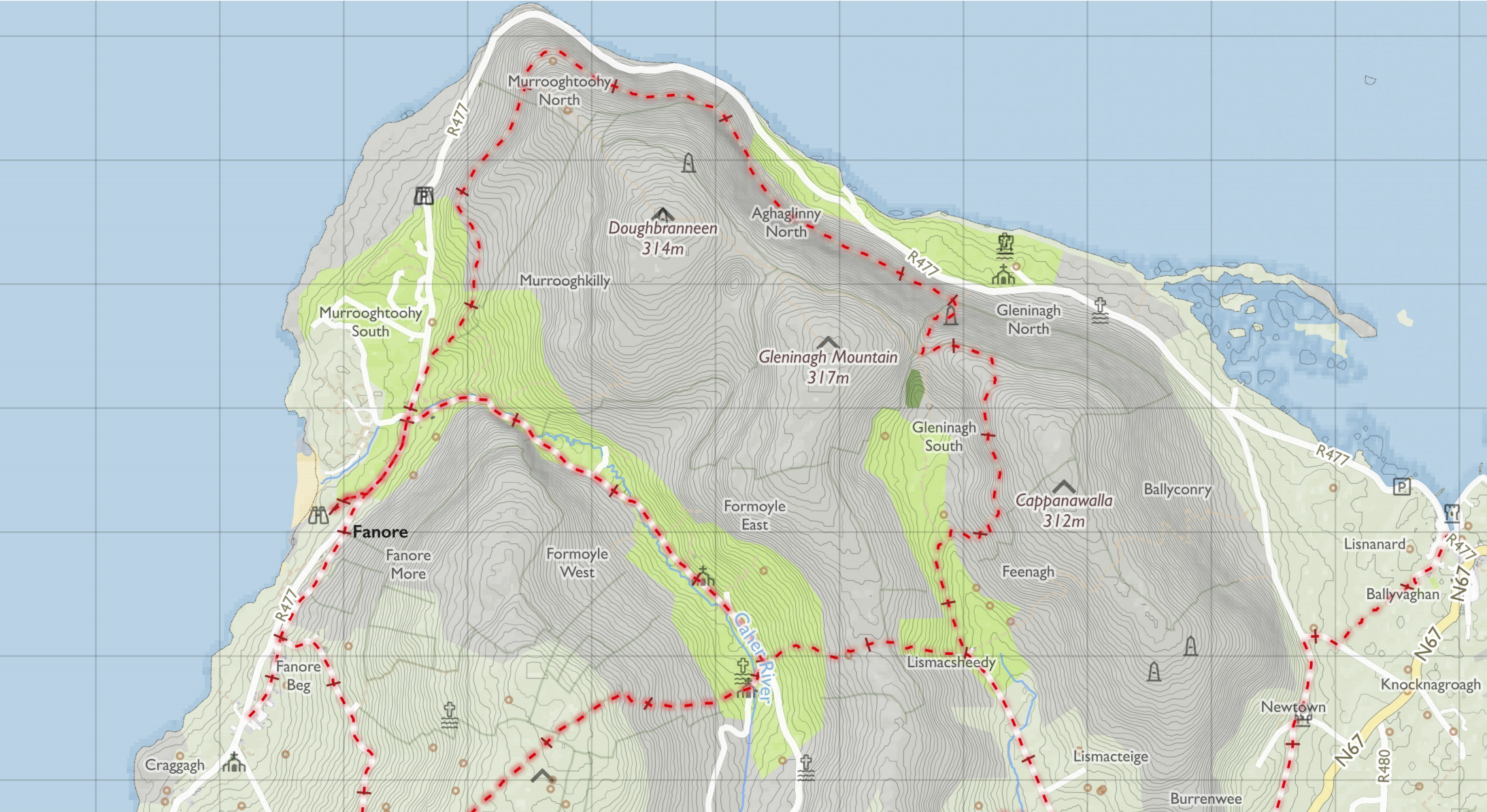
Passing the off-shoot into Ballyvaughan, we continued south for a further 7km or so, completely swallowed in clouds and rain. If one of us walked ahead we promptly vanished. It was weird to feel yourself climbing up hills, and yet not see anything around you. The tracks on this section were a mixture of loose stone and grass, making the walking easy and enjoyable. We were grateful to have such a well defined track to follow, as quite often the next way-marker ahead was invisible from the one we were leaving. The wind was relentless, sweeping away our words before they had even left our mouths, so we spent much of it with our own thoughts and the cows for company.

Day 4: N67 - Corofin
We woke up that morning in Clare’s Rock Hostel. Our final day on this trail - and with marginally better weather than the day before! Back out in the clouds, we spent the day walking was along small back roads down to Corofin with our friends. It was a straight forward day of walking, with the bad weather leaving the roads and fields mostly empty.
A link to The Burren Way video!
I think we didn’t enjoy this trail as much as other trails because the sections of the trail that we started with are very busy, tourist-driven area, and we weren’t ready for that. Once we made it to the quieter areas, the weather had turned against us, leaving us to walk the simplest route to the end. The west coast of Ireland always has very changeable weather because of the Atlantic, but hopefully next time we visit this area we’ll be under some drier skies, and we’ll manage to get a bit more off the beaten paths.
Clare has plenty of indoor accommodation options, so should be easy to plan around whichever stages you’re looking to walk. If you’re looking to camp along this trail, there are official campsites in:
Lahinch: Ocean View Park
Doolin: Aille River Hostel and Camping Doolin, or Nagles Camping and Caravan Park.
Fanore: Fanore Caravan Park
Corofin: Corofin Village Hostel and Campsite
Carron - Hostel only: Clare’s Rock Hostel
If you’re looking to wild camp in Ireland, make sure to learn about Leave No Trace Ireland’s 7 principles. We’ve also written about wild camping in Ireland, which you can read about here.
If you like our blog you can subscribe to it here!
If you really like it, you can support us on Patreon