Killaspugbrone Loop Walk
Starting in the village of Strandhill, this looped walk is a delightful way to pass an couple of hours, offering fantastic views inland towards Knocknarea, Union Wood, and Benbulbin, as well as bringing you right past the early Christian site of Killaspugbrone church. One of my unexpected, personal highlights was to pass so close to Sligo Airport and get to watch planes take off and land right beside me.

Overview
Distance: 7km
Time: 1.5 - 2hrs
Parking:
Strandhill Seafront: here.Trail difficulty: Easy
This coastal trail has no climbs, looping around the small local headland. In some sections the surface underfoot can be quite uneven, but overall the trail is very approachable.
Learn more about trail and hillwalking grades here.Trail quality: 3.8/5
The first 4km - 5km are along rolling sand dune and beach trails, with the final ~2km along roads. All the major road sections have a footpath.Views: 4/5
I think for the area that it is, you couldn’t get nicer views!Buggy/Wheelchair friendly: No
Dogs allowed: On a lead
Way-marking: Purple arrow on a white background
Killaspugbrone Loop is the sister trail to Queen Maeve’s Trail on Knocknarea. While following in the queen’s footsteps takes you climbing up steep cliffs and through towering forests, the other loop takes you right down to the sea shore, out far enough to have beautiful views back at the erratic landscape around you.
Having done Queen Maeve’s trail countless times and enjoyed it immensely, I decided it was time to see where the lower loop would take me. And I was not disappointed.
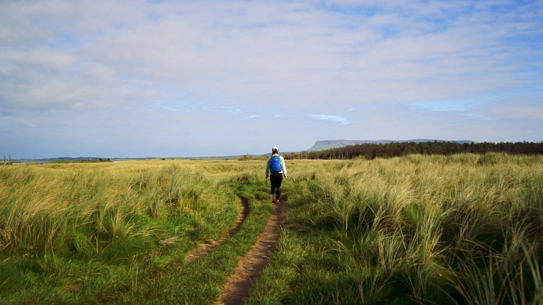
Starting on Strandhill Seafront, the info board for the walk is beside the Wild Atlantic Way sign framing the sea. Passing through the small gap in the wall, the trail goes past the local surf school, through the campsite, and onto the local sand dunes. As I wound my way through the billowing marram grass, I couldn’t stop a smile from spreading across my face. I always love when trails manage to start completely off road in such simple, yet effective way.


The trail crosses from dune paths to sandy beaches and onto short concrete stretches of sea barriers as the route does its best to protect important parts of the habitat, while still bringing you through beautiful areas.
The path then led me towards a high wire fence, a kissing gate set into the corner, large white signs warning from the far side. This is Sligo Airport (a fascinating tiny air strip that you can learn about here. It use to have daily flights from Sligo to Dublin back in the '80’s!).
The warning signs told me to wait if I saw any bright lights turned on, as it meant an aircraft would be taking off or landing. Looking around, I couldn’t even see the lights turned off. Deciding that this still probably meant it was fine to go, I crossed along the bottom of the runway. On reaching the other side I stopped to fix my bag, and then looked up. Lights that had been invisible to me in the grass were now all alight, and I found myself grinning with excitement. I was now on the far side of the runway, so it was safe for me to just stand and wait for whatever was going to happen. Watching two small propellor planes swoop down and take off was so much fun - and it reminds me just how crazy the invention of flying really is.
Walking on, the trail becomes less defined as it leads you out to the top of the headland. On reaching the furthest point out, I sat down beside the way-marker and took in the area around me. Sea birds waded on the rocks and sand barges between me and the two islands that almost close off the mouth of the bay. Looking at Maguins Island, I’m pretty sure I spot some goats on the beach.


Carrying on, the next stop is for Killaspugbrone Church.
Killaspugbrone church is said to have been founded by Saint Patrick in the fifth century. According to local folklore, when Saint Patrick visited the site he tripped on the rough ground I had been navigating and lost his tooth. The tooth was left in the church, and eventually housed in a gold relic - that is now preserved in the National Museum of Ireland.
The present church ruins date back to around 1150 - 1220, with the Irish name of Cill Easpaig Bhróin. Translated, it means “the church of the Bishop Brón”.
A side note: when I saw the English name of this trail, I could not figure out how to pronounce it. It was only on looking at the original Irish that I knew roughly how it should sound. Irish is a language that you typically pronounce exactly as it is spelled, so while I my Irish is very poor, I can break down words and say them, even if I don’t always know what they mean.
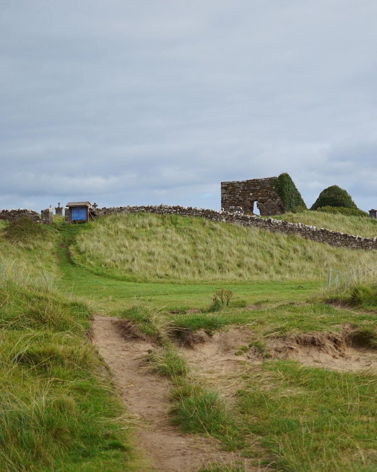


The church ruin was quiet when I arrived, the wind pulling at my hair and making the long grass hiss all around me. Headstones and crosses worn by time and in the midst of their ancient battle with the soft earth and creeping vines were staging their last hurrah, tops just visible and listing to the side.
Following the worn ground of past feet, I walked around the building to where a door once was and stepped inside. The silence surprised me. I’d not realised just how much noise the wind was creating until I walked into air kept still by thick walls. The roof was long gone, the ground nothing more than dirt, but the place still felt special. I stood awhile and wondered about tripping saints and how religion seems like it was once an excuse to live in places where the elements fought like titans and life was made small, grounded.


Leaving the church behind, I descended down onto the beach (with beautiful views back up to the church from the sand) and headed along the shore line. Not far along there's a large red and white stripped pole, with a smaller way-maker beside it pointing back inland through the dunes.
Climbing up and through, there is a short forest section of pines, and you emerge out at the side of a small lane. The trail turns right, following the lane a short bit to pass the other end of the air strip, and then turns off onto a gravel path. The path hugs the edge of the high tide line, a small river estuary currently the only water meandering past.


The turn uphill off the waters edge isn’t completely obvious (if you keep going you can take the next turn up as well).
Reaching the top of the short climb, you’ll find yourself at the petrol station and the Sligo Rugby Club car park, which is the start point for Queen Maeve’s trail across Knocknarea. I mentally wave at the trailhead across the road from me, and keep following the road into town.
From here the route is just along the main road into Strandhill. For a road section, it has footpath the whole way, and it takes the most direct route, and I quicken my pace for this section. When looking at the overall distance of the trail, this 2km-ish section is technically more than I think it is. I think because I walked the first 5km so slowly, soaking up the different views and spending time at the church ruin, that final stretch didn’t feel as much as it was.
While this trail is easy, lowland walking, it is very exposed to the elements. Outside of the summer months, I’d recommend bringing many layers - and even in summer, be prepared for the wild Atlantic to live up to it’s name.
Further exploring
Other trails in the area:
Mountain Hikes:
Favourite Local Coffee / Food Options:
Shells of Strandhill
Rover Coffee Lab, Sligo