Sliabh Bawn is a quiet set of hills outside of the town of Strokestown.
The perfect place for an evening wander or dog walk.
Overview:
County: Roscommon
Distances:
Trim Trail (green): 3km
Yellow Loop Walk: 6.5km
Monastery Trail (blue): 2.7km
Orange Loop Walk: 4km
Heritage Trail (white): 4.3km
Equestrian Trail (pink): 8km
Elevation Gain: 50m - 200m
Format: Linear and Looped Trails
Time: 1 - 3 Hours
Start / End / Parking:
Primary car park has room for about 10 cars, and is the closest to the playground (google maps link).
Secondary parking: A lot of people park along the road in. Where the road widens, there is space for parking along the right-hand shoulder of the road (google maps link). There’s parking for about 10 cars.
Public Transport:
There is no public transport to any of the entrances to Slieve Bawn. There is a local link bus from Strokestown to Scramogue - after which it's a 2km walk to the northerly trail head.Trail difficulty: Easy
These routes use to mostly gravel access roads and small gravel trails.
Read about trail grading in Ireland here.Trail quality: 2/5
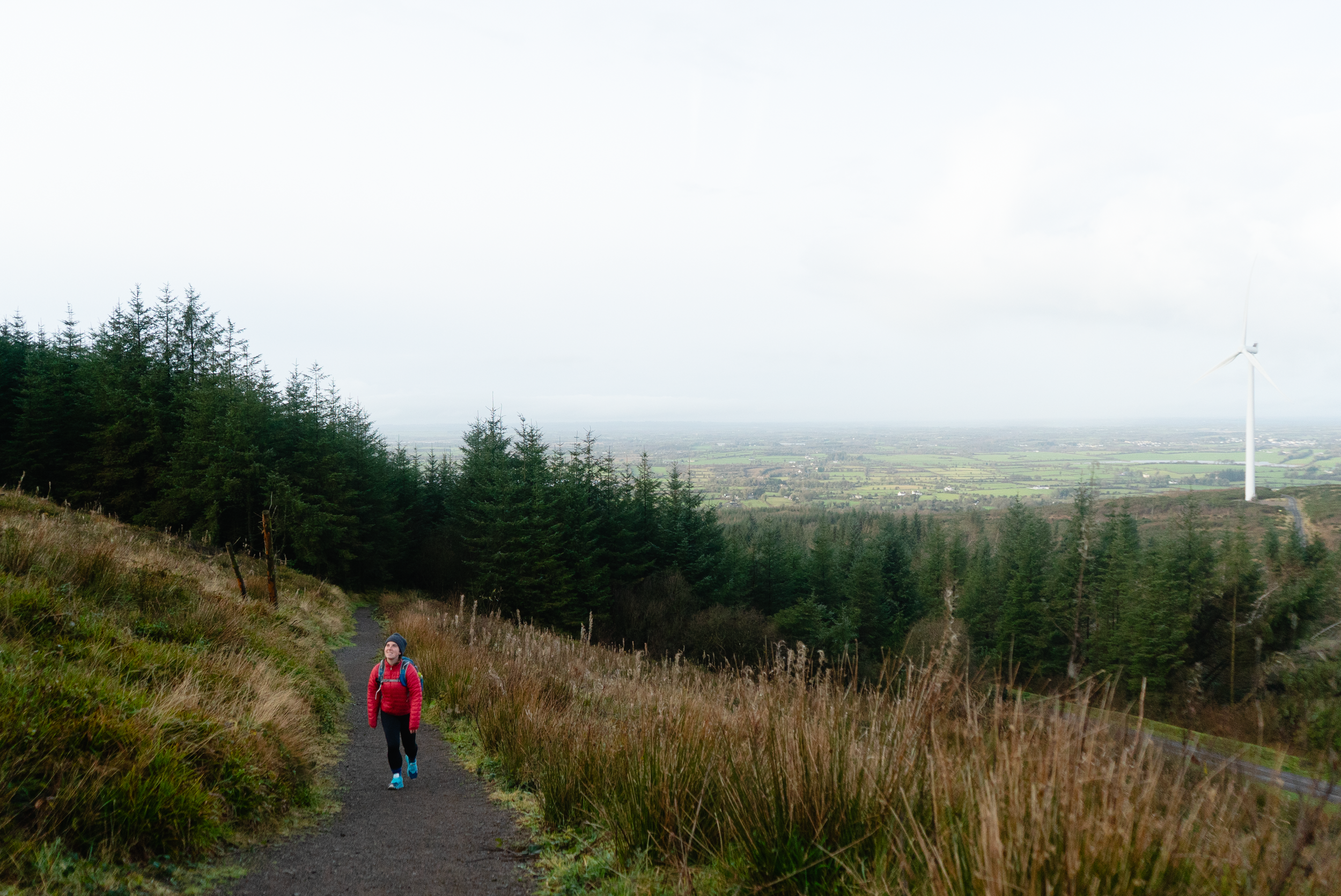
This is a nicely developed recreation area around the wind farm. There are a lot of access roads.Views: 3/5
A mostly forest-focused trail, with some views at the Trooperstown end. Lovely native woodland paths for the southerly section.Buggy/Wheelchair friendly: Not all loops, but certain gravel paths are accessible for buggies. Unsure if wheelchair accessible.
When did I walk this route: December 2025
Dogs allowed: Yes
External Links:

This set of two small hills has become something of a local walk for me. Between these two summits, six different trails have been looped, offering a mix of distances and elevation.
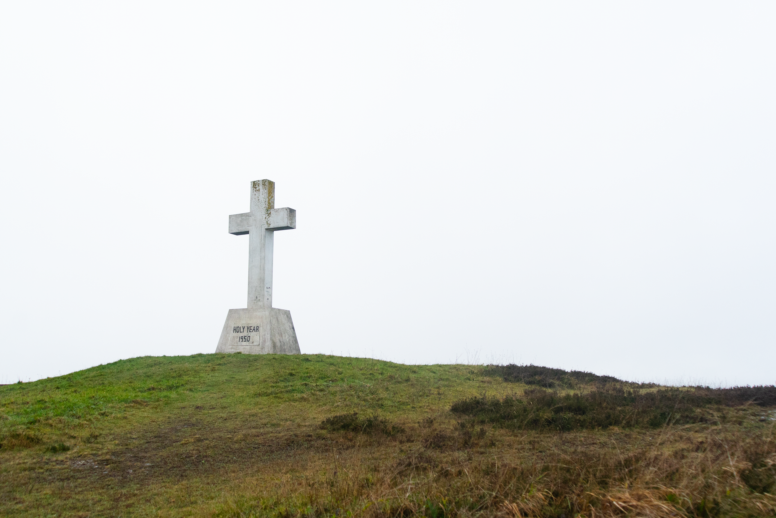
Following the White Heritage Trail from the primary car park, the trail starts with the only steep section, bringing you up to the Holy Cross on the summit of the smaller hill. Erected during the winter of 1950-51, the cross pre-dates all of the forestry and access roads. Donkeys and horses were used to get all of the building materials up to the summit. Like many such crosses across the country, most of the work and funding all came from local people to the area.
This is one of three religious sites on the loop - the second being the mass rock, and the third being an old church ruin.


In the 1950’s, the Government Department of Lands began to buy parcels of land across the two summits for forestry development. While a lot of the forestry in the last few decades has been conifer plantation, there are some small sections of native planting, and each time I visit I come across another new layer of flora or fauna that I wasn’t expecting to meet.
From meeting a large Common Irish Frog on the path, to learning that ladybirds hibernate on gorse bushes, I appreciate these unexpected moments of nature connection.


One of the main reasons that I’ve been on more walks here recently, is because of Laika, the bundle of chaos that we call our dog. She loves a long walk, and she and I can easily walk 8 - 10km here and meet almost no one.
Crossing over to the second and higher summit, you can find a trig point hidden away on the summit. At only 262m, it’s probably one of the smaller hills that you will find a trig point on. However it feels a lot taller than it is, due to just how flat the surrounding boglands are.


Back on the 24th January 2025, Storm Eowyn hit Ireland, causing unprecedented damage across the island. It’s estimated that 24,000 hectares of forestry was damaged in Ireland - over four times that typical annual felling of Coillte (or national forestry company). That means that not only did all of the forestry teams suddenly have to try and process four times as much timber, but because of how it fell in the storm, so much of the wood was cross-loaded on other trees, making it an even slower job to process.
The devastation felt raw last spring - but with some time between now and that initial shock, I’m choosing to see it as an opportunity for goals like 30 for 2030 or the doubling of recreation sites to 500 to reach even further.
Useful links:


Sliabh Bawn is an interesting place for me to write about - because it’s a simple place. In the outdoors, I think there are a few different categories of necessary outdoor spaces. There are the “show-stoppers” that you travel for - offering unique experiences and showcasing the beauty of that area. And there are the places for the local community - the places close by and easily accessed, that give you time and space outside.
For me, Sliabh Bawn falls into the latter category. In the setting sun on a windy day, the views and colours from here can be spectacular, but it is not somewhere that has been developed for its incredible beauty. It's there to give people living in the surrounding area a place to call theirs.


Notes:
December 2025: Storm damage from earlier this year (fallen trees) is still being cleared along the eastern slopes of Sliabh Bawn, impacting the White Trail. This looks to be cleared in the coming months, but at time of publication, it is recommended to detour along the pink (equine) trail for the eastern section.
Further exploring
Other day trails in the area:
Long distance trails:
Favourite Local Coffee / Food Options:
The closest shop to the trail is in Strokestown (SuperValu)
Frank’s Bar is close to the trailhead
Andersons Thatch Pub for traditional music, and a place to park up if you’re in a camper