Official length: 117km
What we walked: 140km (roughly)
Number of days: 5
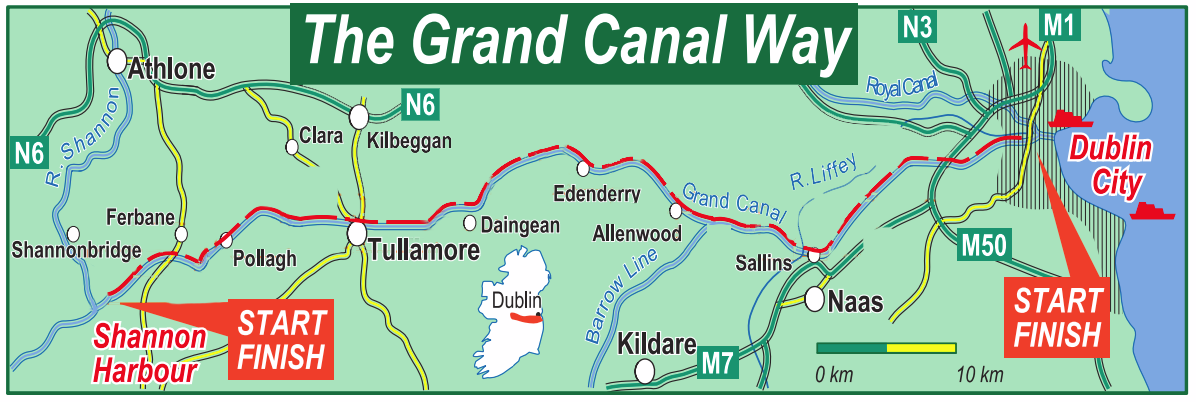
Start point: Shannon Harbour, Co. Offaly
End point: Grand Canal Dock, Dublin city
Trail difficulty: 1/5
Trail Quality: 1.5/5
Views/area: 2/5
Camping/Accommodation: This canal doesn't offer many happy camping options (unless you stop into that amazing golf course!), but it is allowed along the waterway. Finding indoor accommodation should be relatively hassle free - many of the towns along the way had a B&B, but planning ahead would be necessary for this one.
Maps: We’ve made our own Tough Soles maps! These maps are free to use, remix, and redistribute under CC-BY 4.0. All you need to do is attribute us! Here are all the maps we’ve made.
5th May, 2018
Day 1: Shannon Harbour - Tullamore
30-35km
We started mid morning, in drizzle. It was never our plan to walk all that much that first day, but by the time late afternoon arrived we realised that we could probably make it the whole way to Tullamore if we really wanted to. With the drizzle slowly worsening as the day had progressed, camping wasn't sounding all that exciting. A quick accommodation check for Tullamore showed a B&B for only €50 for two people! This is pretty close to hostel prices in Ireland, so we decided to go for it.
We arrived in late, and collapsed into undignified heaps on our room floor. It was a bit of a rude awakening to walk so much that first day, but the sore muscles and heavy limbs also felt good, in a way. It made me feel like we were getting stuck back into it, and after munching a fruitcake we passed out, sleeping for double digit hours.
Day 2: Tullamore - Daingean
15-18km
After our long sleep we left Tullamore late morning and headed off into some more overcast, moody weather. We knew Daingean wasn't too far away, and seeing as it was once the county town of Offaly we expected there to be a bit of life to it.
We were overly optimistic.
After eating our lunch in a silent town square, we walked back up to the canal and prepared ourselves to move on. However, there was a sign boasting of food and coffee available at a golf course "just a stroll down the tow path". When we reached the gate we decided that it didn't look too crazy fancy, and stopped in. The coffee was good, and as we sat there talking to the owner he offered that we could camp on the golf course! It's been a (possibly odd) goal of mine to camp on one of those beautiful greens, and an easy day sounded like the best way to balance out our big walk of the day before. We went to bed early and slept like babies.
Day 3: Daingean - Allenwood
30-35km
The dawn chorus that morning started at 4am, and was the most intense natural wake up call I think I've ever experienced. One bird clearly got a little too swept up in all the singing, and crashed into the tent as it flew past. Thankfully it seemed to right itself pretty fast and continued on.
The weather shifted slightly, with some heavy downpours giving way to short breaks in the clouds and flickers of sunshine. By this point we'd reverted to listening to podcasts, as talking through hoods is never easy, with far more "what?"'s exchanged than full sentences.
The canal passed through a lot of bog - and it was raised above ground level, which is a pretty impressive feat of engineering in such marshy, peaty ground. Apparently they built the base for the canal and the banks out of turf to stop it from sinking. It would have definitely been easier to go around the bog rather than through it, but apparently it was the 1700's and people wanted to prove that they could.
When the canal was a driving trade industry it attracted housing and people to it's banks. Since then, more and more of the tow paths have been paved in some manner to give those who live along it proper road access. Also, I think possibly in places where the canal was seen less like an amenity, and more like an industrial feature, the tow paths were put to multiple uses faster - farm access lanes being a major one. Why I'm saying all this is because I find the canals to be more and more just long road like sections, which really burns the soles (and souls) after any extended period of time.
Reaching Allenwood, we were into the Kildare regions of the trail, and the landscape was becoming a lot more built up than it had been. Quite camping spots were harder to spot, so we decided to stay with friends (and patron - hey Jen!) of ours, and commute for the rest of the trail.
Day 4: Allenwood - Hazelhatch
30-35km
Having slept on a wonderful large couch we left our bags behind, bringing our rain jackets and cameras. What would have been smart was to also look at the weather. Having walked through so so much drizzle, we assumed this would just be it for this whole trail.
It was very very hot that afternoon.
So hot, I cannot stress it enough. There were only two stopping points for the day - Sallins, which was only about 15km along the trail, or Hazelhatch, a further 15+km along. Reaching Sallins at around 2pm we felt it would be wrong to finish so early, and decided to keep going (after the mandatory 99 ice-cream). Sadly there wasn't much shade, but after lots of panting, and standing under trees, we made it. Adamstown (the official end) was only about a further 5km, but we were far too hot and tired to push on. The sun burn was also starting to make itself known - which all felt like very pointed karma for walking the day without our bags; we do own suncream, but it's no good if it's sitting on the floor or a friend's apartment!
To be noted - once the canal had passed the Kildare boundary we did have some much nicer sections of walking; more grassy lanes, some tree lined shady trails, and more benches!
Day 5: Hazelhatch - Grand Canal Dock
20-25km
Once our sunburn had cooled off we hopped on a train back out to finish the trail!
At Adamstown (the official end point listed online) there were actually building works going on at the canal (new bridge construction I think), so there was a bit of an awkward detour and maybe a fence hop or so ... but it was the weekend and there was definitely no building work going on in this blissful sunshine. We then spent the next few hours walking through various suburbs, meeting the thousands of people thronging to a water-space to sunbath and play music at competing levels. We had more ice creams. The canal is definitely seen more like an amenity in the city, and it was nice to walk along it. During my time in Dublin I've lived in 3 different places that were close to this canal, which made the end feel much shorter than I expected, getting to see how different areas had changed in my absence.
Overall
In general, the canal was a pretty okay walk.
Most of the 'trail' is road, gravel - basically hard ground, and pretty un-trail like. Couple that with lots of long straight lines, and not much variance to the landscape, it makes for not the most inspiring multiway trail.
There are definitely one or two very nice sections that would make a great afternoon wander (thinking about Allenwood to Sallins in particular). I would say one of it's main selling point is for people who are looking to start walking more, and are looking for an easy place to build up kilometres. It also seems like a great place to walk your dog, and we definitely met a lot of people along all stages of the trail doing different sports (rowing) or just stretching their legs in the evening.
It was satisfying, on a personal level, to really feel like we were getting somewhere every day, and getting to mark of a high number of kilometres at the end. The project isn't supposed to be about chasing numbers, but sometimes it's still motivating to see easy, definite progress.
What I'd like to do if we had the time/means, would be to go back and analyse the two canal banks - often we found ourselves walking on the worse-looking (tarmac or gravel) side of the canal, but wouldn't want to risk crossing over in case the lovely grassy path on the other side abruptly ended before the next lock or bridge - which we definitely saw happen a few times, but sometimes the other side was definitely passable, with nicer terrain.
But I'm sure a lot of it is going to change over the next 5 years - both canals (the Grand and the Royal) are also in the process of being turned into "cycle-ways" or "green-ways". This means they're being tarmac-ed so it's accessible to all, and makes for an enjoyable cycle. And I think it's a good idea - I think they'll make better green ways than hiking trails. I look forward to seeing them in the future when all the construction work is done, and the canal can be enjoyed by more people.
If you like our blog you can subscribe to it here!
If you really like it, you can support us on Patreon