The Mid Clare Way Overview:
Official length: 148km
What we walked: 114km*
Trail difficulty: 5/5**
Trail Quality: 0/5
Views/area: 1/5
Camping/accommodation: 1/5*** there are B&Bs but almost no places to camp.
Public transport: Ennis is the county town of Clare and is very easy to get to/from. A couple of the towns along the trail also have bus routes.
Maps: We’ve made our own Tough Soles maps! These maps are free to use, remix, and redistribute under CC-BY 4.0. All you need to do is attribute us! Here are the Mid Clare Way maps, and here are all the maps we’ve made.
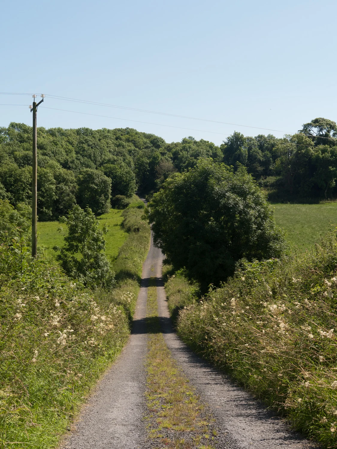
*Uncompleted. Out of what we walked, 93% was on roads.
** Technically the walking is easy, it's all road. But walking long distance on boring roads I find extremely hard because it's long days of hard impact under foot and high hedges that no one can see over.
*** The campsite in Corofin was wonderful, and is not part of these stars.
This is trail 15/42 in our project to walk every single National Waymarked Trail of Ireland. This was us from day 87 - 93.
We started this trail on a sticky evening in Clarecastle. That day we'd spent the whole day on buses, looking out at the sunshine and wishing we were walking in it. On leaving Clarecastle we walked about 8km along roads for two hours, getting into a shady woods around 10pm. I'm not sure if it was the citronella essential oil I'd recently got that kept the midges away, or if we magicked upon a forest that just didn't have any at that time. Who knows, it was great either way. Being the first night back in a tent after a short break, neither of us slept great, but it was an idyllic campsite. The sunset had everywhere painted with burning reds and oranges in such strong shades it didn't look real.
Our morning weather wasn't as exciting, with heavy grey clouds hanging around. But at least it wasn't dripping on us. We walked a slow hour into New-Market-on-Furgus, which is a town off at the end of a little awkward limb. We stopped for ... 2 hours for coffee and food, and then turned around to walk back up the arm we'd just walked down, heading towards Quin.
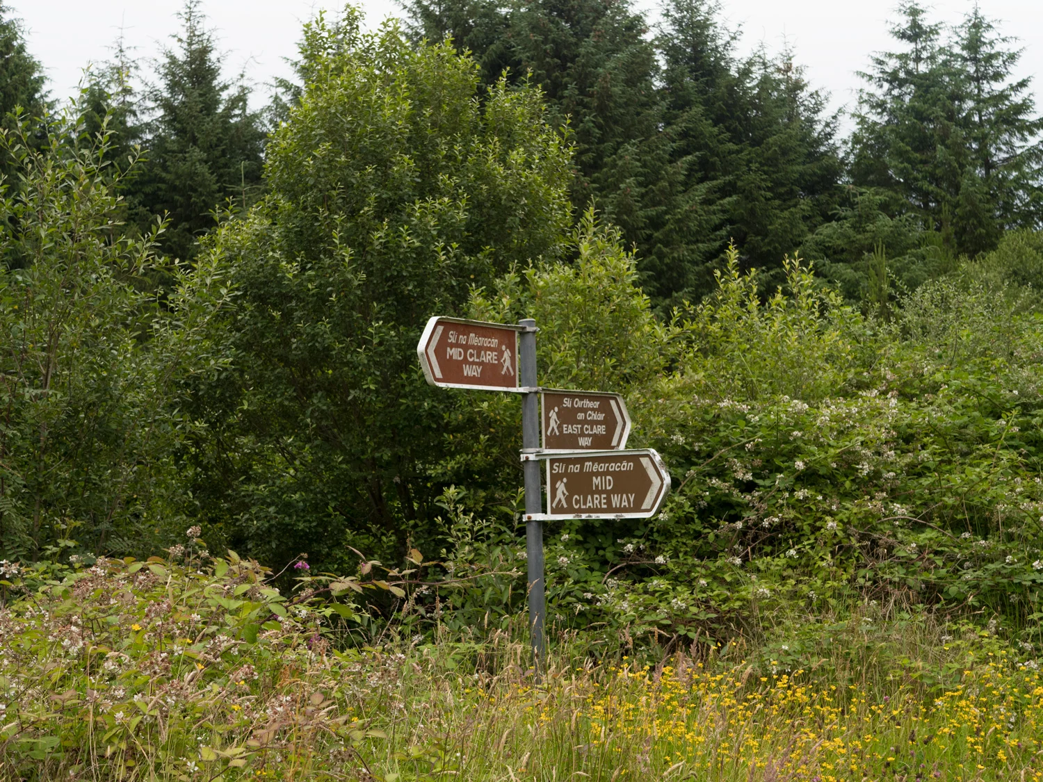
The Mid clare Way is apparently also known as the Foxglove Way, which in my opinion is a much nicer name. Online it says it's about 150km, so should take us a week to walk, maybe more while we find our walking legs again. The walk up to Quin was uneventful, with plenty of road, and not much else that was exciting. Not really sure of the scale on the map, we expected to spend most of the afternoon walking up to Quinn. We got there at 1:25pm. Sitting outside a pub and we looked around. We looked at the heavy rain clouds above us. We then looked at the B&B sign hanging off the pub gable. Back to the passers by, up to the rain clouds, over to the B&B sign.
In our defence, we hadn't really planned out this walk at all, leaving all decisions to the last minute. It was pretty useful to take the afternoon off wandering around the amazing castle/friary ruins of Quin and then properly looking at the maps for the rest of this trail.
It was around dinner time that we realised that we may have made a bad choice of trail to come back to after a break. The trail is almost exclusively road. We quietly died a little inside. As karma for staying in a B&B when we didn't 1000% need to, neither of us slept, and the shower was broken, so ice cold water was the only option.
Leaving Quin, we continued north-east (anti-clockwise around Ennis) and had another day on road. We stopped and ate a fruitcake for lunch on a verge. Then walked on some more road. Eventually, late that afternoon we ended up on a track winding our way up the side of a small mountain. It was great to not have hedges on either side of us and be able to have a bit of a view. As with most of the walks, this trail took us very close to the summit, but then went around it as opposed to over. For a change, we decided to go up. Even though it was only 278meters, the view was amazing. We could see the Shannon estuary, the hills that the East Clare Way follows, and mountains from Galway. We felt a bit better after spending the whole day walking on roads.
That evening it started to drizzle. We were in the only properly off road section of the day; a forest that we planned on camping in. It was wet, and marshy, and generally not amazing, but we found a pretty good spot that was dry and solid feeling, and but a little closer to a forestry road than we would usually settle for. Just as we were falling asleep, we heard a car drive up somewhere nearby, and doors open. We sat there silently in the tent, wondering why someone would drive out into such a middle of nowhere place. I find it pretty scary actually, when random cars stop near our campsites. There are no wild animals in Ireland that offer any threat, almost no harmful plants we should watch out for, but people are scary. I know, it's silly. What are they going to do, really. But it always gets me, and as we sit there we start to hear someone really hitting something hard. Carl got up and went to sit outside the tent, just in case. I sat there thinking about someone silently approaching the tent and killing him.
Turns out it was some guys driving up to take out their anger on an old wreck of a car that was parked up here. They broke off the wing mirrors and knocked the car off the stone it was using as a jack. And then they left. I don't know if they saw us. I doubt it. But it took a while to go to sleep.
At 5:30am I woke to Carl sitting up beside me, staring at the floor of the tent. There was water there. Inside the tent. A wet tent is soul crushing, and we hurriedly, sleepily, packed up our things, trying to keep everything from getting any wetter. We didn't pack the tent down into it's bag but left it in the stretchy section of Carl's backpack, hoping that it might drip dry a little more. We were walking by 6am. It was consistently raining - it hadn't stopped since 6pm the evening before. As we walked through the final stretch of forest, I was glad that we'd picked the spot that we did - everywhere else was far worse. We might not have slept at all.
As we left the forest, we realised that our little hill was actually in a cloud. What I'm sure would have been pretty decent views were now just shadows and greyness, but it was still rather pretty, and we stumbled on bleary-eyed. I will say that the roads were extremely quiet at that time of morning, and we made it pretty much the whole way to Crusheen with the roads to ourselves.
At Crusheen we bought multiple coffees and sat in the sheltered smoking area of a closed pub trying to semi dry ourselves (it still hadn't stopped raining). We sat there for an hour, and decided that we probably weren't going to start feeling more human any time soon, so got up again. When we got up, we then had to make the decision if we were going to keep going along the trail. Crusheen has a bus every hour that could take us to pretty much anywhere, and we couldn't see anywhere on our maps that we could camp. It was early in the day so we decided to keep walking, and if we wanted to call it quits later we could try thumb a lift into Ennis.
That day was as boring and un-trail like as the day before. The roads were twisty and the hedges too tall to see over. Thankfully, the walk from Crusheen to Ruan went through the Dromore Nature Reserve, and although the trail was still mostly on roads we were at least surrounded by nature and lakes, which lifted our spirits a bit. It also had a great information center filled with information about the local wildlife, and had a whiteboard to keep track of sightings of different animals. The guy there was nice enough to fill one of our water bottles.
We continued out of the nature reserve and arrived in Ruan. We were pretty wrecked, and really didn't want to walk. Google maps was then kind enough to show us a campsite up in Corofin. Corofin isn't on the trail, but it looked to be only 5km off. We decided to aim for there, and if we found somewhere along the way then we would stop there instead. Two hours later we were standing in Corofin Camping, with wet bags at our feet and many caravans reversing around us. It's a small site, and being so close to the Burren it's easy for it to be busy. But we got a spot, and put up our still-wet tent. Even though the drizzle hadn't stopped, we hoped that leaving it alone for as long as possible would let it dry off even a small bit. So we sat around the place like zombies, waiting for the time to pass so we could go to bed. In my sleep deprived state I made one rookie mistake. The campsite had hot showers, so I decided to wash the cold damp away. It was great, until I was half way through washing my hair and I realised that there was no way my very long mop of hair was going to dry before I had to get into my sleeping bag. You live and learn. We took a day at the campsite to revive ourselves, and sat around reading and watched the rain move on to other parts.


Moving on from the campsite was hard, but we started walking again. And the weather gods changed tack. The sun started splitting the rocks. No amount of sun cream could stop the gentle cooking feeling of my skin while we trudged along more empty twisting lanes. The day dragged. At one point while we were panting and sitting on a garden wall, I wrote a note of how the trail was going so I had something to reference when writing this blog post. This is the note:
I'm sitting in the shade on a road somewhere in the middle of Clare, and we're both just kind of done. We've walked 15 trails, 1,300km and recently just a lot of road. Their reaches a point where you've thought you already hit the wall, but actually you're about to plough into it as you're looking the wrong way.
So ... It clearly wasn't going well. We kept walking for another day. And there was a highlight that afternoon - we came to a very old high-cross and church with a tower. It was pretty beautiful, and the cows stayed to the other side of the field. That night we camped on a patch of grass beside a tiny slip-way into a lake, and ate another fruit cake.
We started early in the morning. And still the trail was almost purely road. This was day 6 of walking (7 incl. the rest day at the campsite), and we could count out the handful of times we'd walked on anything that wasn't tarmac. Arriving at a petrol station in Connolly, we bought another cake as our breakfast/lunch. Using the pedometer on my phone, we counted up what we'd walked since starting, and counted the off-road sections on our maps.
According to our calculations, we'd walked 114.1km in total. Being as generous to the off-road sections as we could, they totalled to 8.3km. Which meant that 93% of the trail had been along road. So we looked at each other, and called it quits.
I went into the petrol station to ask the woman who ran it about any buses in the area, and within 20minutes she'd organised a lift for us into Ennis. A big thank you to her and the woman with the crying twins who brought us in.
The Burren Way was another trail in the area, so we got on a bus and headed to Lahinch.


We’ve made our own Tough Soles maps! These maps are free to use, remix, and redistribute under CC-BY 4.0. All you need to do is attribute us! Here are the Mid Clare Way maps, and here are all the maps we’ve made.
If you like our blog you can subscribe to it here!
If you really like it, you can support us on Patreon