The Sheep's Head Way Overview:
Official length: 100km - 200km (175km being most regularly quoted distance)
What we walked: unknown
Number of days: 4 - 7+
Start/end points: Bantry is the typical start/end point, but accessible from many locations
Trail difficulty: 3.9/5
Trail Quality: 5/5
Views/area: 5/5
Camping/Accommodation: We didn't see a huge number of ideal camping spots, but this is for two reasons; it was very early spring when we walked the trail, and therefore very wet; and, we weren't camping for this trail! So we weren't actively searching for them.
From what I've seen and heard the landscape on the Sheep's Head goes through unbelievable transformations throughout the seasons, so in summer there's probably much more to choose from.
As for indoor accommodation there seemed to be plenty of B&Bs/small rental apartments all along the trail. We were lucky enough to stay with friends for the entire trail.Maps: We’ve made our own Tough Soles maps! These maps are free to use, remix, and redistribute under CC-BY 4.0. All you need to do is attribute us! Here are the Sheep’s Head Way maps, and here are all the maps we’ve made.
If you look at the map at the top of the blog post, the shape of the trail looks pretty simple, and just taking this shape the trail is roughly 100km. However, along the peninsula there are countless looped walks criss-crossing from north to south side, and all along the trail, some of which are starting to be counted as part of the main trail. While Elvis (our little yellow man) was our main guide, we also walked a couple of these other loops and trails in order to get back to easy pickup points/finish closer to where we were staying. Some of these cross-trails even have orange Elvis' (instead of yellow) along sections to show that they can be used to connect onto the main trail. It was a pretty amazing layout of waymarkers. At one pointed Carl said that 'you couldn't swing a goat for fear of hitting a Waymarker on the Sheep's Head Peninusla'.
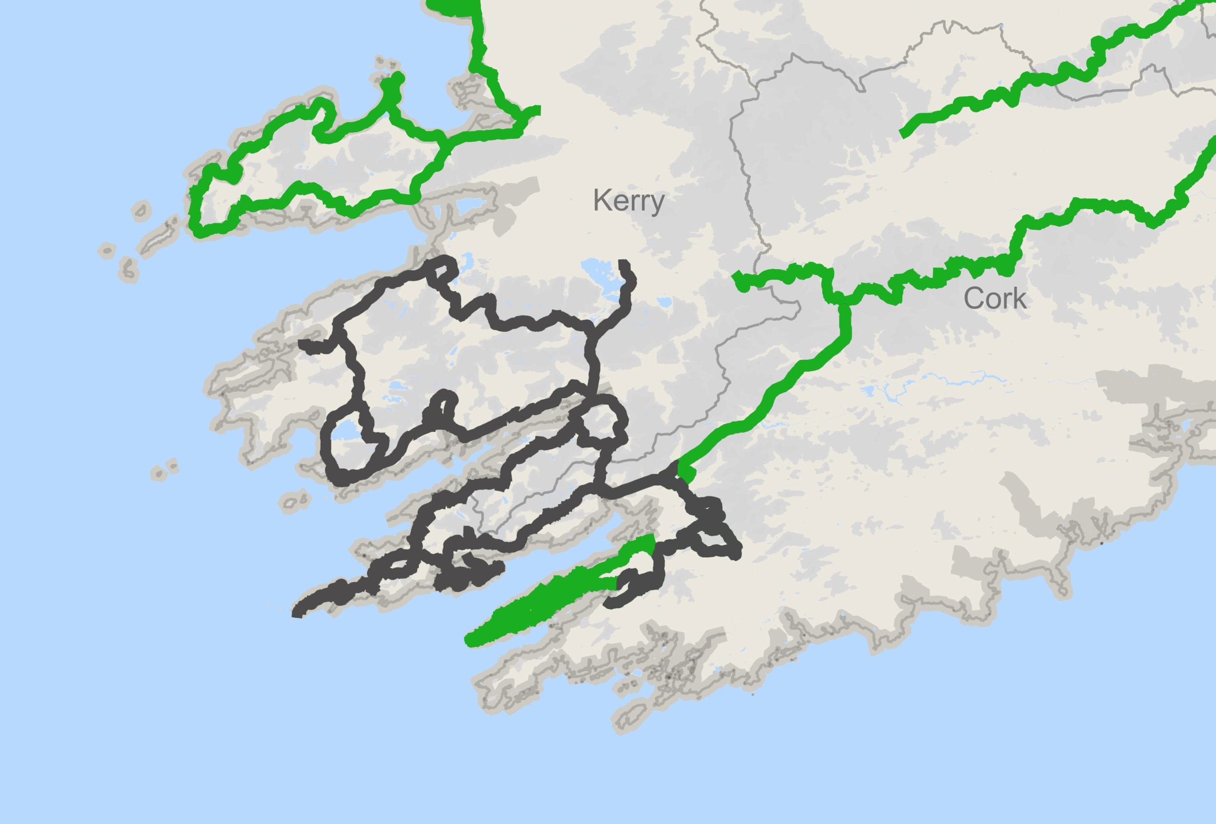
In contrast, here is a cropped-in section of our general overview map that we've built. The green is what we've walked - and we've filled in how much of the Sheep's Head Way we've completed. Included in this map is the loop that extends down onto the Mizen head, and connector trails all the way back to the Beara Way. The connector bits are not part of the main trails, and therefore not on our list. They're link sections for the Beara Breifne Way and the E8 walking route. As of yet we're unsure if we want to walk these bits, but we decide to leave them on the map until we figure that bit out.
There’s only one section of the main route that we haven’t walked yet; from Durris to Bantry.
Day 0: Arriving to West Cork
The trail that we walked on our way down to cork was the Slí Gaeltacht Mhuscraí - a 3 day trail starting in Milstreet and ending in Kealkill. While probably not the toughest trail we will ever walk, it had plenty of climbing and mud, leading to a less than comfortable reacquaintance with our walking legs. Being cold and snowy we'd opted to splash out and stay indoors that trail. The early nights were more than necessary, often followed by late starts as we struggled to leave the warm cocoons we'd collapsed into the night before. Through this rough re-awakening, our bodies definitely seized up a bit, for me starting with my left hip, and then some pain and stiffness in my right knee. Thinking back to when we first started the project a year ago, it's hard to remember how much discomfort we actually went through - clear thinking hindered by both the strong rose-tint that any strenuous hiking acquires after completion, and just mostly because we didn't know what to expect a year ago, so we probably just accepted everything. If I concentrate, I do remember a lot of foot pain (mostly in the form of blisters), and hip bruises from the backpack straps. This time around I soon realised that the anti-inflammatory cream I'd originally bought for my foot injury works it's magic on all parts of the body! With slightly numbed limbs everything was easier.
Also, it's strange how the Slí Gaeltacht Mhuscraí felt like our first trail of this year, when it was definitely our second (having taken part in the Croagh Patrick Heritage Trail walking festival earlier in the month). I apologise if I'm recapping too much, but Carl graciously wrote the first two trail blog posts of 2018 (he lost a bet), so it feels like a long time since I've typed away about our wandering. Also, turns out he was much better sticking to a publishing deadline. Maybe this will motivate me to improve on own my delivery times!
Arriving at our end point on the S.G.M., we met Peter Clarke - one of our amazing patrons. He's also a hiker, and sketches the places he walks through. I love his work, and you can find it on his HikeLines blog. The other half of our wonderful hosts for this trail was Amanda, who's currently on a mission to document all the Holy Wells of Cork. You'd be hard pressed to find a more interesting pair. Their cosy house of books, sleepy cats, and wonderful wildlife became our base for the week to come, and we couldn't have imagined a better place in our wildest dreams.
Amanda has also written a guide book of the trail (Walking the Sheep's Head Way), which we found incredibly useful and used as our guide to understanding the history and the landscape we were passing through. On other trails in the past we've definitely had the sad experience of walking through a landscape, and then learning afterwards all the amazing history we missed because we hadn't read up enough on the place before hand. It was nice to appreciate the history while standing in front of it!
Day 1: Bantry - Boolteenagh - Glanlough - Mass Path
There was sunshine, there was the sea. There were mountains, and there were two sleepy hikers.
Starting off in Bantry, the trail takes you up through the grounds of the beautiful Bantry House - where we immediately stopped for more coffee. The gardens then lead to a hotel, and at that point you're pretty much out of the town and wandering down a country lanes. It doesn’t take too long to enter into some quiet fields, following a gentle uphill. Then you see her. A Blessed Virgin Mary - or the fun abbreviation we were introduced to while in west cork: the BVM. She’s up on a small cliff face with many religious artefacts and trinkets adorning the lower reachable nooks and crannies. There's also a holy well there, and having only been properly introduced to their magic the night before we lingered longer than usual, especially as it was such a well kept hillside.
A short return to small winding roads, and you pass a turn down onto a beach. From the guide book we knew to take a quick detour to the beach to see some rare rock formations made out of mud stone. Carl of course also found some perfect stones to skip.
Still on that gentle uphill (which we might have had us a bit out of breath), we pass a gentleman who wiggles his eyebrows at us as he drives past. I don't think I've ever written that sentence before, but I can also say that it was the most positive and joy-filled eyebrow wiggle I've ever received. After this inspired encounter, we reached Boolteenagh. We sat at the car park and ate an early lunch, deciding to fly the drone out along the peaks of the peninsula. The geography of the area is pretty special; the peninsula has a ridge running down it's full length creating a spine for the headland. Along this ridge there is a fault in the rock, creating a small u shaped trough all along it that the northern side of the trail uses as a guide for the route. It all looked amazing in the sunshine. Motivated to move again we shook ourselves awake and pushed on.
That afternoon we experienced some faux-summit-sighs. Have you ever been out walking, and you can see the top of the hill your climbing just a few hundred meters ahead. However, on getting there you realise that hidden behind your current "summit" there’s another high point (the actual summit) just a little further on? Well, we experienced that a number of times on our first day as we wound our way through moorish bog and orange scrub.
What made these long climbs funnier was the fact that after reaching the real top of the hill, we'd see the trail wind it's way back down into a valley below us, and then snake up the far hill. These minor moments of despair were quickly forgotten as the views were spectacular all the way along - I’d keep stopping to take pictures, only to get to an even better vantage point slightly further along the trail, slightly higher up. As I mentioned, the terrain was very boggy in parts, and the ground can be quite unforgiving when you step off the path. Beware of the boot-swallowing moss!
There were two lakes to this stretch of trail. The first was Lough na Fuille (spelling uncertain) which translates to Lake of Blood. The story associated with the lake tells of when cattle were driven onto the hillsides to graze in summer, they would often drink at the lake that filled this mountain shoulder. However, sometimes the lake ran dry, and many years ago on a summers day the sun was so hot there was no water left. The cattle went made with thirst and killed each other, leaving no animal alive, filling the land with blood, and forever renaming the area to be Lough na Fuille.
When we visited there was a solid outline of where a lake might be, but the rushes were tall and covered the hollow completely, making me unsure whether there was water there or not. I don't know if it was knowing the story that caused the place to feel strange, or if it held that aura on it's own. We took a shorter break than planned, and headed back into the sun.
Our second lake was Glanlough (meaning clean lake in Irish), and was hidden in one of the lower valleys we would descend to that day. This is not the first"Glanlough" we've come across during this project, and definitely not the last. And while we didn't need a drink it did give us a sense of relief, as it meant that we were getting closer to our end point for the day.
Climbing upwards again, we got to watch the sun start to set as we wandered along the top of the ridge line. It was at one of the deepest and widest saddles that we came across the Mass Path. This path has been here as long as houses have been on the peninsula. The north side of the headland is quite rugged, while the south side has wider plains between the mountains and the sea, and feeling more sheltered from the elements. This lead to shops, churches, and schools being built on the south side of the peninsula, with people walking across this low saddle in the mountains to get to mass. They would carry their good shoes when crossing the boggy land, only putting them on once the church came into view. The mass path has it's own markers leading you across the hillside, and this is where we walked down off the trail to end the day.
Day 2: Rain rest day
One of the main reasons that we walked that very first day after arriving off of the S.G.M. was because we'd seen the weather forecast for the coming week. On day two, we sat indoors and listened to the rain rolling down the windows, and enjoyed it. You wouldn't believe the level of satisfaction you can feel from being indoors and dry, while it rains outside. This also gave us a chance to edit a video together for the coming weekend, and catch up on some more sleep. I’d forgotten how tiring just walking can be. It would take more than a couple of days to adjust to this life style again. As we planned the rest of the trail it was clear that we were going to either have to walk some extra long days, or break it down into more numerous short days. We decided slow and short was the way forward for us!
Day 3: Ahakista - Kilcrohane - Letterwest
Looking up at the ridge-line we'd planned on walking, all we could see were clouds. Dark, very-wet-looking clouds. Even down at sea level where we were, the air felt completely saturated. A brief chat around the breakfast table, and we decided to mix up our route order, keeping to low ground for the day. Peter was going to walk with us, and we all set off heading towards the end of the peninsula (clockwise) along the south side. I thought that because we were walking the lower section of the trail it would be one of the less spectacular areas; not every section of a walk can be beautiful. But I was (happily) extremely wrong - the trail hugged the coast line as much as it could, and the small cliffs, choppy water, and low lying fog made for an intimate wildness. The greens and yellows of lichen looked so bright against the dark rocks and overcast skies. It managed to turn bad weather into magical walking. Along one part of the shore there’s a small lake just barely separated from the sea by a spit of rocky beach. On it two swans have lived for many years. The old story goes that back when the Spanish were trading off the Irish coast two Spanish princes were caught in a storm and shipwrecked, perishing in the cold water. They then turned into swans and have lived on the lake by the shore ever since.
We ate our lunch overlooked the crashing waves, beside a rock pool that looked like it was a painting from some beautiful folklore book. From there on we walked up towards Letterwest, with a sharp uphill only intensified by the weather deciding to unleash one last downpour upon us.


Part 2 coming soon!
If you want to skip ahead, the video of the full trail is already out! As well as that, we have a beautiful drone video of some of the amazing sites to see along the trail.
We’ve made our own Tough Soles maps! These maps are free to use, remix, and redistribute under CC-BY 4.0. All you need to do is attribute us! Here are the Sheep’s Head Way maps, and here are all the maps we’ve made.
If you like our blog you can subscribe to it here!
If you really like it, you can support us on Patreon