
Overview
County: Offaly
Official length: 37km
What we walked: Around 30 - 37km
Start point: Cadamstown
End point: Lemanaghan
Time: 1 - 2 days
Trail difficulty: 2/5
Trail quality: 3/5
Views/area: 3.5/5
Most common walking surfaces: Some woodland trails, farm fields, and tarmac/roads.
Camping/accommodation: There are probably accommodation (B&B) options in Kilcormac if you are looking to divide the trail in two, and some B&Bs around Cadamstown. At the Lemanaghan end there didn’t look to be much.
In regards to camping, the trail crosses the grand canal, which has plenty of camping options, but this means walking the majority of the trail on day one, leaving maybe 10km for day two.Transport: As far as we are aware, there’s no public transport to Cadamstown. At the start/end point in Cadamstown there is a car park and information boards, along with benches and grassy areas.
In Lemanaghan there is a local link bus that runs three times a day (leaving Lemanaghan at 06:35, 09:10, and 14:40), taking you into the town of Clara, that has a train station that runs to either Dublin or Galway.Maps: Here’s a link to the Tough Soles Offaly Way Maps!
These maps are free to use, remix, and redistribute under CC-BY 4.0. All you need to do is attribute us! If you’re interested in all our maps, check out here.

The Offaly Way was our last short trail, and after twisting my ankle the week before it seemed like the only logical option. The only tricky bit was the location - “the midlands” can be a bit difficult to travel around without a car. The more desolate end for public transport was the southern point, so we organised a lift with a family member (the true heroes of this whole project!) and made our way to Cadamstown on Monday morning.
Cadamstown is a village on the north side of the Slieve Bloom Mountains. As we step out of the car and wander between the different information boards of the car park, we smile as we notice benches, a beautiful river, grassy areas - this place was pretty perfect. We say goodbye, wave to the retreating car, and sit down again on a bench. How exactly was it that we started these things? Laughing at ourselves, we cross the road to the other side of the river, and start along a small dirt trail (which briefly turns into someones immaculately kept garden that backs onto the river), almost immediately entering a deciduous woodland with bluebells all over the ground. Carl stops for a minute and I continue on around the bend, then stop to try and fix my camera strap - I’d brought slightly the wrong camera gear and it wasn’t fitting together. A mild panic creeps up as I fight with the strap, and I manage to stop myself before I go completely crazy. I stand and take a breath. I close my eyes, then open them again and look at the beautiful forest. See, everything is beautiful, and there is nothing to be stressed about.
I’ve had some “walking stress”, as Tough Soles season slowly approached. I think when there’s a big thing coming, but there’s nothing you can really do about it until it comes, can cause some internal mental worrying, and as the time had come closer and closer I’d started to feel more worried and stressed about starting back walking again. If I was in the right frame of mind when the stress was creeping up I’d remind myself that walking isn’t exactly a skill I can forget how to do. So as I started to panic over all the small things that weren’t perfect I reached for the calm that I knew was in me somewhere, and reminded myself that I still knew how to walk. And that was all we really needed to do - just one foot in front of the other.


We spend the next six kilometres along the river bank, and it’s wonderful. This wasn’t what we’d been expecting at all. And when the walking is good, walking is so easy. We hit a 4km road section that’s just one long, straight, road. We’d noticed how straight the roads were in the drive there, and it was even straighter when we were walking it. But it wasn’t very busy, and a couple of cars laters we reached our turn off into the bog. We sat down for a minute and looked at the maps. We were giddy with how far we’d come so easily, and were bitten by the trail bug. Could we do this whole trail in one day? We’d only started walking at 12:45pm, so had assumed that we’d have to camp - plus, we hadn’t wanted to push my healing ankle. But here we were, almost in the middle of the trail. At the far end of the trail there was an 11km stretch along an R-road, and then a train station. The last train was at 20:45, and on such a major-looking road we would surely be able to thumb a lift. It was such an exciting idea. Our completionist dreams were flying all over the place. We decided to wait and see how long the bog would take us to walk through - you can never time a bog. There were also multiple routes laid out on the map as to how we could go through the bog - should we take the shortest route, or the longer, winding route that would pass a 5,000BC tomb? Less then two minutes later we rounded a corner, and immediately saw a cyclist. What? Three steps later, and we were on a tarmac path, and that made up our minds for us - the shortest route! We ploughed on along the tarmac, complaining to each other how people are always trying to find ways to “improve” places that might not have needed to be changed. I think most of our complaining was purely out of surprise - we were expecting a bog, and while we were in a bog, we were also surrounded by kids on bikes and babies crying, which is definitely not what we were planning on. It wasn’t until we were reaching the far side of the bog that we started to appreciate how it had changed - there was a sculpture park that invited kids to climb and explore. There was a bike rental shop, cafe, information centre, toilets - we’d never seen such a lively bogland area. And by creating these very structured paths, people were far less likely to stray and damage fragile rare bog plants and wildlife. If we’d left earlier at the start, I can imagine us stopping, having coffee, and thinking of this place as the best thing in the world.
On the far side of the bog we were back onto small roads, and these ones were even more quite than before. We crossed narrow gauge railway tracks, once used in bogs all over the country. Eventually, we reached the grand canal. It was almost exactly a year since we’d walked the canal and come across this trail-crossing point. We remember that, back when we were doing the Canal we considered walking the short north arm of the Offaly Way, just to have it done.
Where we reach the canal to the left is road, to the right is grass. Of course, our trail leads us to the left. It’s coming up on 19:30, and there’s still a fair distance of trail to walk. As we walk our couple of kilometres along the canal, we start to count the boxes on our map of how many kilometres we have left. We know it’s too many for us to get there in time, but we’re so bad at stopping, that we keep going until it’s our turn off. We sit for 15 minutes, and admit that the only smart thing to do is walk back along the canal to the good camping spots we’d just seen, and finish the trail in the morning. Thinking back to us sitting there, our stubbornness almost makes me laugh. We’ve so rarely - possibly, never before - turned around and gone back to the better camp site. But we managed to get over ourselves, and back we went along the canal. We were planning on only going back about half way, as we’d seen an old disused railway bridge that we could walk across, and camp on the grassy, secluded far bank. As the bridge starts to get closer, we start to rub our eyes more and more. The bridge is “open”.
This old rail bridge that we had thought wasn’t even in use any more, was very much still active, and could pivot so that the canal was then open for barges to pass through. That far away, beautiful grass bank was no longer going to be our beautiful home for the night. We nervously laughed and thanked our stubbornness that we’d taken so long to agree to walk back, otherwise we might have stranded ourselves on the wrong side of the canal.
Our bridge kerfuffle meant that we had to continue walking back to where the Offaly Way originally joined the canal, and take that right turn onto the grass. A couple of hundred metres further on and the tow path widens. We’d found our home for the night.


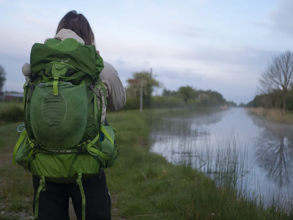
We both slept unexpectedly well for our first night back in the tent, and woke with the birds at 5am - although we remained cocooned in our sleeping bags until 6:30am. Once we climbed outside, we quietly watched the mist rise off the water, and the sky flow through shades of pink, blue and gold. Eventually we packed up the tent and started moving, eating some breakfast bars as we walked that stretch of canal for the fourth and final time.
From the canal to the end is again just roads, but they were completely empty, and we wound our way past high old walled gardens and tumbling down sheds and slowly woke up.


As we got close to the end we realised that we were going to arrive in perfect time for the morning Local Link Bus. I have developed a very deep, slightly odd, love for this bus service. Usually just a minibus, these local link buses connect small towns that are otherwise completely impossible to get to or from. We arrived at the cross roads that makes up Lemanaghan with less than five minutes to spare, filming a fast ending for the video and taking a second to admire the amazing-looking monastic settlement there. I do wish we’d had slightly more time to fully explore that, but I was also incredibly grateful to be able to hop in a tiny bus, chat to locals, and smile as the feeling slowly sank in - we’d completed our 36th trail! Only 6 more to go ….
If you like our blog you can subscribe to it here!
If you really like it, you can support us on Patreon