
Overview
County: Cork/Kerry Border
Official length: 206km
What we walked: 150km
Start/End point: Usually Kenmare or Glengarriff (circular/looped trail)
Trail difficulty: 4/5
Trail quality: 4/5
Most common walking surfaces: Wild mountains! With some short road sections.
Views/area: 5/5
Camping/accommodation: So many campsites, it was amazing. Indoor accommodation also available along the trail, although booking ahead is advised as it’s a very popular area.
Maps: We’ve made our own Tough Soles maps! These maps are free to use, remix, and redistribute under CC-BY 4.0. Here are the Beara Way maps, and here are all the maps we’ve made.
Trail Days:
Day 1: Kenmare - Lauragh // 25km
Day 2: Lauragh - Eyeries // 27km
Day 3: Eyeries - Castletownebere // 20km
Day 4: Castletownebere - Adrigole // 20km
Day 5: Adrigole - Glengarriff // 20km
Day 6: Glengarriff - Kenmare // 25km
Day 7: Rest Day!
Day 8: Dursey Island // 5 - 10km
The above distances are rough estimates from when we were walking!
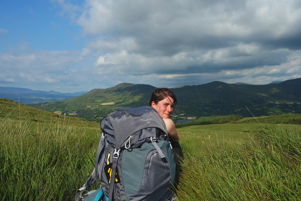
The Beara Way is one of Ireland’s longest single trails - the longest route being the Kerry Way. This was our second last trail when walking all 42 of Ireland’s National Waymarked Trails. Starting it, we were nervous, tired, excited, and so much more. We walked this trail anti-clockwise, starting in Kenmare and looping around through Lauragh, Eyeries, Castletownbere, Adrigole, Glengarriff, and back to Kenmare. One of the great perks of walking a trail with defined stages that you can follow (if you want to) is that once you arrive at your campsite for the evening, there’s a surprising amount of time to put the feet up and relax! We walked the bulk of the distance over 6 days, which was pushing it, but had an amazing time.

Day 1: Kenmare - Lauragh
As usual, we started this trail in the late afternoon (why change after all this time?) and made our way out of Kenmare heading west. We were on small roads for several kilometres as we made our way out of the town and its surroundings, and into the more mountainous sections of the peninsula. After about 6km of roads gradually leading us uphill, we turned off road and onto beautiful mountainside. The trail twists its way over some steep hills, and our late start had the unintentional benefit of giving us the most incredible sunset views out over parts of the Beara and Iveragh Peninsula. As the sun goes down and the trail hits a road section, we raced the fading twilight to Creveen Lodge campsite, pitching up after 10pm in the near dark and collapsing into our sleeping bags.


Day 2: Lauragh - Eyeries
As we packed up our tent we decided that this campsite had one of the best views in Ireland - our tent had looked out at the sea all night, and the sunrise made the mountains glow. In the campsite kitchen that morning we chatted with other people travelling or visiting the area, relaxing in the homely feeling of the place. Making it back onto the trail, we stick to it for a couple of kilometres before turning off it again to stop into a cafe. I think an unintentional side-effect of this project has been our funding of all small, countryside cafes we pass. We love taking breaks where we can talk to locals and learn something about the area or trail ahead, and we have a deep love of coffee.
Once re-caffeinated, we were back onto hiking trails, walking along some hidden passages in large laurel groves before making it back out onto open hillside once more. The wild sections on this trail are so good that the short road sections are immediately forgotten about.

As the day goes on, we cross amazing rock fields before passing through the village of Ardgroom, which roughly marks our half way point for the day. From there it’s more ridge-top hillside, followed by a beautiful twisting coastal trail. We passed old lifeguard stations and other ruined buildings being slowly worn away by the wind and rain of the Irish coast. Thankfully that evening the coast had nothing stronger than a sunny breeze in store for us. Our end point for the day was Eyeries, a brightly coloured village filled with bunting and feeling like a festival was about to start. We stop at the pub and chat to a lovely dutch couple who have been visiting Ireland for many years and tell them about our adventure so far.
That night, we stay in Solas Mor camping, featuring more stunning sunsets out over the water. It was there we met Ciarán de Baróid and his partner Cora, who regaled us with incredible, almost impossible to believe adventures that they went on through the 70’s and beyond. I went to sleep dreaming of jungles and hitch-hiking to India.

Day 3: Eyeries - Castletownebere
Leaving Eyeries, we hadn’t decided what our end point would be for that day. Coming into the trail, we had thought to go to Allihies. However, while walking the past two day’s we’d heard a lot of talk about the hostel closing down (it was going through a change of ownership, and didn’t open in 2019. I don’t know if it’s opening in the future). It’s mid-morning by the time we’re walking up the valley between Miskish Mountain and Knockoura, where the trail creates a figure-eight style shape, the westerly half of the peninsula being the smaller loop and the east of the peninsula being the larger loop. The sun was beating down on us, and as we made our way into the valley we felt like we were melting. Standing at the junction in the trail, we flipped a coin, and after a lot of humming and hawing, decided to take the short route to Castletownbere. Crossing through the mountains on zigzagging old tracks, the views are once again beautiful. Reaching the crest, we get views down to the town of Castletownbere, and our spirits are instantly lifted by seeing our end point in sight. It’s as we’re crossing these hillsides that we meet A Woman A Foot, on her own hike of the Beara Way. We’d started following each other online, and it was such a happy turn of fate that we had taken this turn and bumped into her on this mountainside. (She has a fantastic website where she writes about her experiences solo hiking, gear tips, and so much more!)

We spent an hour or so descending into the town, and wandered through it not sure where to go, as we hadn’t planned this far ahead. Carl had been having a bad hiking head day - when the exhaustion hits, and the idea of wild camping makes you feel stressed and anxious as opposed to happy and adventurous. We’ve both experienced these kinds of days throughout the project, and I think we’ve been lucky enough to have our low days at different times, so that we have the other person to help us keep going. Heading back out of town, we found a B&B with an available room, and had a relaxing night inside.
Day 4: Castletownebere - Adrigole
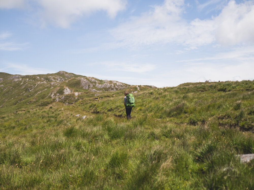
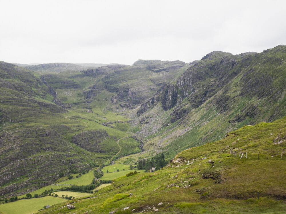
Well rested, we set out from Castletownbere towards Adrigole. The weather had turned on us that morning, so we left with rain jackets and backpack covers on. As the trail climbs back up into the hills we enter the clouds, following old tracks across rocky ground. The cloud cover is thick enough that when I let Carl walk ahead of me while I film, he starts to disappear instantly, and is invisible less than 50m away. However, as the clouds start to lift a bit, we get to see what an amazing valley we had walked into.

Mountains still capped with clouds, their sheer sides slope down to create a rocky valley with a gushing river cascading down through it. It’s still raining on and off as we move through it, clouds sporadically dipping down to fill the valley, before opening up again. Moving on, we cross bare rocks that remind us of the karst landscape we experienced on the Burren Way. Out of the valley we stay high on the mountainside and work out way around the mountain, until we reach the valley inlet of Adrigole, and so walk down to the coast once more to our campsite for the evening, the Hungry Hill Lodge and Campsite.
As we pitch up the tent for the evening, we feel like we’re doing everything the same way we have for the past 1000 pitches, but something must have gone wrong, as our poles break at the top joint of the two pole sections. Unable to fix it on the fly, we change from camping to staying in the hostel half of Hungry Hill and thank our blessings they still had room.
This tent had made it through the 3 years of this project, plus our previous adventures of 6 weeks on the Camino Del Norte, and smaller camping trips. It had certainly lived a life and served us well. After talking to the guys in Great Outdoors, we learnt that to get new tent poles for the older model we had of the MSR Hubba Hubba was going to be a large chunk of what a straight up new tent would cost us, and would also take much longer. And so we ordered a new tent that would be shipped to meet us in between finishing this trail, and starting our final trail, the Wicklow Way.
We were also lucky enough to have this happen while we were on the section of trail that had hostels along it, and after some searching booked ourselves into a hostel for the following night in Glengarriff. As we made ourselves some dinner, even a broken tent couldn’t dampen how amazing the day of walking had been.

Day 5: Adrigole - Glengarriff
Leaving Adrigole we were straight into some forests and the upwards climb. We walked on a mixture of trails and boreens, the climb slowly becoming steeper and steeper. After a while we’re able to look back at the inlet that is Adrigole. There’s something wonderful about being able to look back and see where you’ve come from.


We climb about 560m up from the coastline that morning, nearly up to the peak of Nareera, and between the two sugarloaf peaks. Up there, between these three points lies Lough Tobernavaha. We stop and sit here for a kind of lunch break (digestives), tired from the climb up, and also in awe of how beautiful the place is.
As we sit and rest, another hiking couple crest the far pass and walk down the trail. We wave a greeting and they stop momentarily to say hello, but then keep moving as they let us know that there’s 50 people behind them. We don’t get a chance to ask any questions before they disappear, and we’re left sitting there wondering who we’re going to meet next.
Finishing our break, we put our packs back on and start moving again. As we round the lake we hear something on the breeze, and look up to see 50 singing german women crest the gap. We keep moving towards them, bemused by the sight before us. Ranging in ages from 30s to mid 80s, these women were all out hiking the trail together. Each carrying a very small backpack, they were camping out without tents (most had bivvy bags). As each walked passed us they nodded and said hello, and we found ourselves bobbing and hello-ing for a solid 5 minutes. They were all smiling and moving gently through the landscape, not a bead of sweat on their brows after the long climb they just completed, or out of breath in any way - with enough breath to walk along as a long choir, german lyrics rising and falling as the breeze pulled them away. Looking back, it feels very surreal, and I remember at the time Carl and I walking on and not fully believing what we had just experienced.


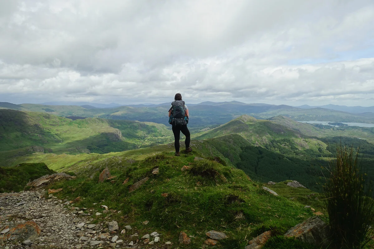
Topping out at the far saddle, the mountains to our right just fell away and the whole island of ireland opened up in front of us. To say it was incredible feels like a snub. It was beautiful, and we couldn’t have been more happy.
As always, what goes up must come down, and the following 5km are on dirt tracks and trails as we make it down to the valley floor. We stop at Coomarkane Visitor Centre for coffee (also a campsite and has cabins), before walking another 5 -6km down the offshoot to Glengarriff. We check into our hostel and find some food, our minds full of mountains and german songs.
Day 6: Glengarriff - Kenmare
As is to happen in hostels, we ended up in a dorm with a strong snorer, and then the skies joined in and a thunderstorm rolled through, so we started our final day a bit groggier than planned. The rain from the storm wasn’t completely gone, so we left with our wet weather gear in place, and began the final stretch up to Kenmare.


The majority of our route that day was along roads. Comparing our route to other people walking, many were walking from Glengarriff to Kenmare, and not walking this final section down to connect the two - or, they were walking from Lauragh down to Glengarriff, cutting off the Kenmare loop completely.
We start the day in beautiful forests, and all the earthy colours are shining from the storm the night before. We wade through long wet grass and slowly cross our final saddle between two hills, and then we’re onto small lanes for our walk back into kenmare. At the split that allows for the bypassing of Kenmare we find a very old info board and map of the trail. The Beara Way was built in 1995 by 400 landowners around the peninsula. It’s always incredible to think of just how many people are involved in each trail, and how much work goes into establishing these routes that we get to follow. Just want to say a huge thank you to anyone involved in helping people access the outdoors, you are deeply appreciated.
Turning towards Kenmare, the final kilometres follow small roads back into town. We squelch our way there, and check into the hostel.
Day 7: Rest Day
After 6 days of hiking, we spent a day in Kenmare sleeping and eating pastries from the french bakery, Maison Gourmet. Who knew there was an incredible french bakery tucked away in Kerry! We may have gone in more than once.
Day 8: Dursey Island
We couldn’t leave without visiting Ireland’s only cable car, and so for our final day on the peninsula we headed out to Dursey Island.
Dursey island is 6.5km long and 1.5km wide. It is separated from the mainland by a fast flowing, and dangerous waterway known as Dursey Sound, which while we were there buffeted us with the muffled cries of seagulls, and whipped away voices as fast as you could hear them. Currently, what makes this island so unique is the fact that it is accessible by Ireland’s only cable car. Originally opened in 1969, the Dursey Island cable car remains, to this day, the most used means of transport across to the island. Even more unusual, it is the only cable car that traverses open seawater in all of Europe. While we travelled across, door held closed with a small hook, we rocked as the weather assailed the outside of cab. Looking into the corner, I noticed a small bottle of holy water, and an extract from a bible.
This island has a facinating history - with connections to the O’Sullivan Beare family, who’s history has become so famous it has inspired the creation of a 500km walking route across Ireland. Their castle, that once stood on this island in 1602, was destroyed in the Nine Years War with the British.
While we were there, we wandered almost blindly, silhouettes starting to disappear mere feet away from you. Something we’ve come to believe is that weather in Ireland seems to be as much a part of the landscape, as a force that is shaping it. Boots squelching, socks soaking, rain running off your hood and straight down your face. It’s not always a joy, but it certainly builds character. And, sometimes, it just feels like the right way to experience that place. You will never know that amazing feeling of relief, and the breath stolen from your chest, as when the clouds part after a lifetime of rain, and everything in front of you just glows.
We didn’t see much of Dursey Island, but we went there, we wandered in the windswept silence, felt the peace and power that lives out here beside the Atlantic, and then we left it.
Afterthoughts
The route we walked on the Beara Way is a striped back version - we took the route option to walk across the peninsula from Eyeries - Castletownebere, as opposed to looping out around the bottom of the peninsula, and we visited one of the two possible island off-shoots. Some day, I’d love for us to get to go back and visit Beara Island, drink a few more coffees, and take our time a little bit more. We had a fantastic time walking this trail, and would happily recommend it to anyone looking for one of Ireland’s tougher, wild trails.
Compared to the Kerry Way or Dingle Way, we found this route to be much quieter - when we were out on the trail we would meet a couple of people a day, and many of the villages along the route are smaller (I think this route is often hiked clockwise, so around lunchtime we would meet a couple of people walking against us, and we would get to swap little bits of info). This trail is just as well kept as the Kerry and Dingle Ways, but it also more wild feeling. It was such an amazing area that while I was writing this blog post I found myself trying to think of other ways to say ‘beautiful’, as I was worried I was repeating myself too much.
If you like our blog you can subscribe to it here!
If you really like it, you can support us on Patreon